Where was Middle Street?
High Street - Now Called Church Street
"But on he 12th of August, 1561, Queen Elizabeth visited the place, and accepted an entertainment from the borough; lodging for several days, as it is said, in 'about the middle of High Street,' or what is now, I think, called Church Street, where there still exist some curious old houses, built in the style of the period, which I shall have great pleasure in pointing out when we visit the town." (Lindsey, W. H. Season at Harwich with Excursions by Land and Water, 1851)
High Street was Part of Church Street
Lindsey elaborates on which street was the High Street: "But, to continue near the last mentioned stairs, till very recently stood a house, known as the Government house; it was formerly called the King’s house, and belonged to the navy, and latterly to the clerk of the cheque: this was at the end of High Street, a continuation of Church Street. The turning in the direction of the jetty, and separating Church from High Street, is the site where the old market was held but, as observes Taylor, not very convenient for the purpose, on account of its narrowness." (Lindsey, W. H. Season at Harwich with Excursions by Land and Water, 1851, p.150)
Which Harwich Road was the High-Street?
The High Street is a metonym for the concept (and frequently the street name) of the primary business street of a town or city. Already in Middle English the word 'high' denoted a metaphorical meaning of excellence or superior rank. 'High' also applied to roads as they improved: 'highway' was a new term taken up by the church and their vestries during the 17th century. It seems logical that the High-Street was where the Church and the most important businesses were located. (Brett Hammond, 2017)
Central Part of the High-Street - Not Middle!
"...queen Elizabeth was here, and accepted an entertainment from the burgers, lodging several days at a house in the central part of High-street". (Wright, Thomas The County of Essex, vol.2, London, 1835, p.819)
Church Street - The Former High Street
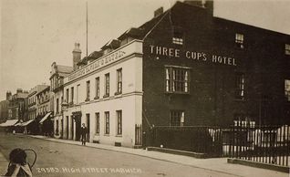
1907 Postcard showing 'Church Street' was also known locally as 'High Street'
The Three Cups "expanded to fill a prominent location in the former 'High Street', and by the end of the 19th century it was called the 'Three Cups Estate'..." In Harwich most pubs have clustered around the established commercial area: Church Street - (the former High Street) - and Market Street. (Woods, Brian Harwich, A Town of Many Pubs, Dovercourt, 2002, p.26, 32 & 48)
Church Street is Middle Street or 'Middle of Church Street?'
It was not in the progress 1579, but in 1562, that Queen Elizabeth visited Harwich for several days, and "lay in a house about the middle of Church Street." (Cutler, Richard A Historical and Archaeological Sketch of the Town Harwich, Church Street Harwich, c.1863, p.68-69)
Also see the 'Outline Plan of Harwich, c. 1690
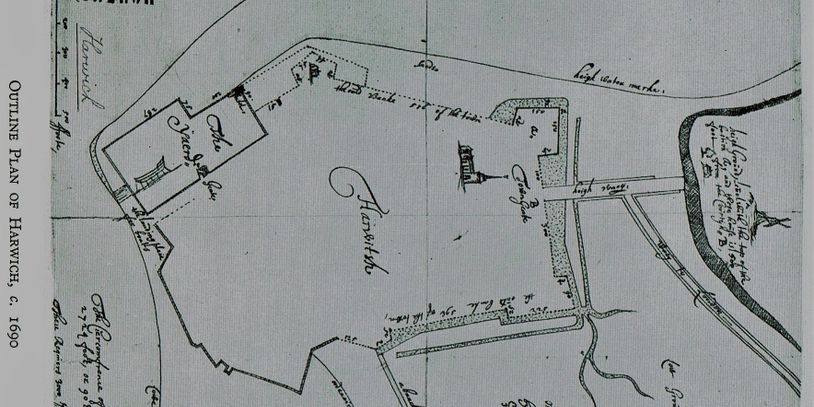
which clearly identifies 'Heigh Waey' or Hight Street, entering the 'Town Gate', directly in line with the front of St Nicholas Church. (Arnott, W.G. Orwell Estuary, The Story of the Ipswich River, Ipswich, 1954, pl.4, courtesy of Mr. Bowden-Smith, British Museum)
Confirmation of Doubt
Further Research
Within the book: Just Thinking About Harwich, by A. R. Carter and Brian Woods, printed in Harwich in 1997 there is a section dedicated to the location of the High Street. Their research seems to point to the High Street now being known as Church Street, with the middle section called Middle Street, not Kings Head Street:
"THE HIGH STREET:
Is something of a controversial topic, as it later came to be associated with Harwich's 'Mayflower-ology'. Previous research led to the identification of Christopher Jones's house, with the subsequent placement of a commemorative plaque on the property in Kings Head St. But as it is all tied in with the location of the 'High St', has the correct building been identified? Was King's Head St. really the former High St? The author believes some doubt exists on this point, so let us now examine the evidence to see what we can establish.
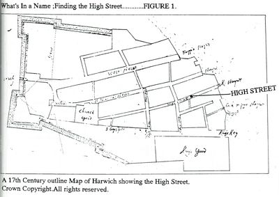
The link between the Jones family and the High St. comes primarily from the will of Christopher Jones Senior dated 1578, which mentions his house 'next to the water', together with a quay, and located in the High Street. Later research uncovered a late 17th century map of Harwich (reproduced on FIGURE 1.) which certainly shows our Kings Head St. as the 'High St.' However, can this be regarded as conclusive? [Are the locations written in a rushed later hand?]
Firstly let us consider a rental (or rate) survey of Harwich dated 1603 which suggests albeit not conclusively) that Christopher Jones was then living in Church St. Further along, the 1656 Manorial survey does not, of course, show our Capt. Jones... (he had left Harwich in 1611)... but curiously enough several of the adjoining property owners, from 1603, are still listed, and on this occasion are clearly on the West side of CHURCH St. The 1656 survey does not record a High Street, and what is listed in the survey as East St. is presumably our Kings Head St. This is just sufficient to cast some doubt on the whole issue, but for further verification let us go back to even earlier times.
The muniments of Harwich Town council includes various leases and documents from medieval times, the majority of the records being indexed in the 'Calendar of Muniments' published by the Borough Council in 1931. So what can we discover in these records that will shed further light on the site of the High St? Well, two conveyances are of particular relevance:
Ref. HB 39/1: From John Baryngton to margaret his wife & others. A tenement abutting on Le Hyestrete E. (East) and Le Westrete W (West). dated 10 May 1446.
Ref. HB 39/35; From John Digelott and John att Hyll to John Deve of Harwich. A tenement and garden.... abutting on Le Hyestreet N (North) and la Westreet S.W. (South west). dated 4 Nov. 1456.
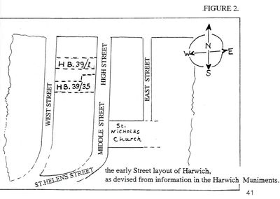
Therefore if we transfer this information to the street map shown on Figure 2, we clearly see that High Street was at one time part of our present Church St. Further muniments record that in 1386 and 1478 Church St was then known as 'Middle Street' - (which seems logical in a topographical sense) - and beyond this we find, in 1388, Eststrate-later known as East St; and listed as such in the 1656 Manorial survey. All the records suggest that from earliest times up to around 1600 Church Street was divided into three sections, namely:
1. High St. at the upper end.
2. The Middle St., the section from Church and Guildhall is situated, and
[Confirmation of this exists within the will of Thomas Kempster dated 12 June 1711 (National Archives Ref PROB 11/522/212): "... my capital messuage or inn called by the name or sign of the Three Cups in Harwich aforesaid, in a certain street there called the Church Street or Middle Street."]
3. St Helens St. the section from Church Lane leading down into West St, incorporating what is now Wellington Rd.
Then, to the east of Church Street came East St. which appears in all the records and surveys until the 18th century when it changes its name to Kings Head Street.
Further research is needed for positive confirmation, but there is now enough data to say at least that the Jones family more probably lived at the top of Church St. (on the west side?) rather than in Kings Head Street." (Carter, A. R. & Wood, Brian Just Thinking About Harwich, Harwich, 1997, p.40-41 & 43)